Optimal Future for the Irrigation Agriculture Under Climate Change in the Fergana Valley, Central Asia-Juniper Publishers
Juniper Publishers- Open Access Journal of Environmental Sciences & Natural Resources
Optimal Future for the Irrigation Agriculture Under Climate Change in the Fergana Valley, Central Asia
Authored by Nikolai Dronin
Abstract
The changes in irrigational water deficit in the Fergana Valley, Central Asia were evaluated based on different scenarios of climate changes well as land & water management. The Fergana Valley is located within the Syr Darya River basin and shared by three countries: Uzbekistan, Kyrgyzstan and Tajikistan. The main driver of the Valley economy has been cotton farming, which consumes large amount of water. The current volatile state of irrigational agricultures caused by restricted transboundary water flow in the cotton-growing season from upstream Kyrgyzstan. In the Fergana Valley local farmers can't afford modern management of their land and water resources which become overexploited and polluted. Apart from the current shortages, climate change may alter projected water demand increases within the Valley. Two climatic and land & water use scenarios were combined in the water deficit models for three time periods: the 2020s, 2050s and 2080s. The authors suggest that climatic scenario SRES/A2 could be related to the "business as usual” scenario of land and water management (including the unstable transboundary water flow) while the climatic scenario SRES/B1 corresponds to the "optimal” scenario of land & water management in the Fergana Valley, which would require restoration of international water regulation.
Keywords: climate change; Irrigation; Agriculture; Central Asia; Fergana Valley; Water demand; Water management optimization
Introduction
Fergana Valley is located in the Syr Darya basin, the density of Valley's population is one the highest in Central Asia region (14 million people, or 636 people per km2). The Valley is shared by Uzbekistan, Kyrgyzstan, Tajikistan, competing for its water resources used for irrigated agriculture and hydropower (Figure 1). The risk of conflicts over water between upstream and downstream countries has been repeatedly estimated as very high [1,2]. Over the past fifteen years a number of small water conflicts arose due to the shortages of land and water resources Weinthal [3]. Local conflicts over water, especially in multiethnic districts, are likely to grow into full-scale military conflicts [4]. Before 1993 the annual agreem ents provided barter exchanges of water used for irrigation in summer for fuels consumed in winter, between upstream Kyrgyzstan and downstream Uzbekistan and Kazakhstan, regulated the relationships between the countries. The barter system collapsed, supposedly, due to the concerns over reliability of its implementation. Kyrgyzstan had to switch its Toktogul reservoir from "irrigation” to "energy” mode because of the internal energy deficit in winter period. The "irrigation” mode supposes that 75% of its annual water amount is released from the reservoir during the summer months. Meanwhile summer water release from the reservoir currently is reduced to only 45% of the total annual amount, falling short of the downstream demand by 2-3 bln m3 [5].
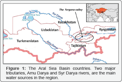
At the local level the land and water mismanagement is responsible for widespread soil salinization and water logging in the Fergana Valley. During the reforms land was distributed among local people, who have insufficient skills of irrigation farming [6]. Around 19% of agricultural lands are saline. Productivity of cotton crop decreases by 10-20% on slightly saline soils, 30-40% on medium saline soils, and 60-70% on highly saline soils [7]. Between 1990 and 2005, agricultural water productivity (on cotton plantations) dropped by two to three times [8,9]. About 3000-3500 m3/ha of water are spent to flush saline soils, with two to four flashings normally required after the end of harvest in November- December, when the level of ground water is the lowest [10]. This results in water consumption of 11,000 and 14,000 m3/ha [11] vs. 7,700 m3/ha global average (FAO, Aquastat).
The majority of drainage systems in the region are in disrepair with outdated water storage and distribution infrastructure [9]. Currently the ground water table is shallower than 2 Mon 25 to 50% irrigated lands, what creates water logging risks [6,12]. Higher groundwater salinity increases concentration of the total dissolved salts in drinking water up to 3.5 g/l in some places, while the safe level set by the Uzbek government is above 1 g/l (Small et al., 2001). Water logging leads to bacterial and chemical (e.g., pesticide) pollution of drinking water [12]. Climate change may increase water demand in the Fergana Valley. Local meteorological data shows consistent warming trend during 1970-2005 without significant precipitation trend [8,13]. The Hydrometeorology Service of Uzbekistan [14] estimated temperature growth of 0.5oC to 3.5oC in different parts of the Aral Sea basin countries with moderate, up to 10%, increase in precipitation in the 2030s. Similarly, Ososkova et al. [15] projected 3oC temperature increase by the 2050s. According to the Hydrometeorology Service of Uzbekistan, the Syrdarya River flow may be around 6-10% lower by 2050 with increased frequency of extreme [16]. Unstable Trans boundary water supply, poor land and water management under the condition of climate change may seriously deteriorate social-economic situation in the Fergana Valley. We have elaborated the optimal scenario for the Fergana Valley to investigate its capacity to copy with growing water deficit on the irrigated lands suggesting that climatic scenarios and water & land management scenarios can be associated.
Data and Methodology
Climate Scenarios
The scenarios of future climate (2020s, 2050s, and 2080s) for three countries sharing the area adjacent to the Fergana Valley were developed based on multiple circulation models (GCMs) runs. Simulations of five different GCMs (CGCM2, CSIROmk2, ECHam4, DOE PCM and HadCM3) were used to account for model-related data uncertainty. Four IPCCscenarios: A1, A2, B1, and B2 [17] were employed for each of the GCMs to account for different paths of socio-economic development. A superposition of different GCM simulations and SRES scenarios [18] provided the range of future weather patterns for the countries. The 1961-1990 monthly temperature, precipitation, and water vapor pressure at the surface level, gridded at the 0.5ax0.5ageographical latitude and longitude scale [18] were used for the base climate. The current and future climate data was temporarily downscaled with Andrew Friend's [19] stochastic weather generator. Finally, the daily data was aggregated into five indices: mean annual temperature and precipitation, mean temperature, precipitation and potential evapo transpiration for the growing season -from April to September. More details of the modeling were provided by Kirilenko et al. [20].
Modeling the water deficit for irrigationin the Fergana Valley
The developed GIS-based model of the Fergana Valley's water allocation for irrigation was used to identify the irrigated lands with the potential water shortage. The GIS includes 3 major layers: land use structure, irrigation infrastructure, soil types and average ground water level. The intersection of the land use cover and irrigation layers resulted in 560 polygons representing complexes of the agricultural fields irrigated by different canals. We simulated the flow of irrigation water in the canals to identify the polygons facing water shortage in different climate conditions, accounting for the following factors:
i. Tran boundary water supply (TS) - amount of water which enters the Fergana Valley from the Kyrgyzstan's Toktogul and the Uzbekistan's Andijan reservoirs;
ii. The policy of water redistribution(WR) in the fields;
iii. Efficiency of water delivery to the fields (E); and
iv. Crop composition (C).
For the first factor (TS), the following three conditions of trans boundary water supply were used:
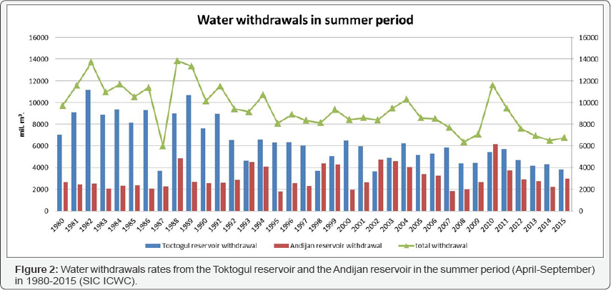
a. TS1 - optimal irrigational water availability based on the operation of the both Toktogul and Andijan water reservoirs in the irrigation mode (Figure 2), as it was before 1993).
b. TS2- business as usual relatively unfavorable condition of water supply when the Toktogul reservoir operates in the energy production mode while the Andijan reservoir discharges the maximal possible water to compensate for the reduced water flow to the Fergana valley(as it wasin1998, 2002, (Figure 2).
c. TS3 - water management aimed to produce energy in winter period with minimal water flow from both reservoirs what could happen in adry year (for example, in 1987, 20132015, (Figure 2).
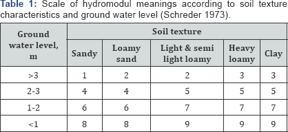
The second water redistribution factor (WR) is presented by two options in the model. The current "top-down" approach to distribute water among the fields (WR1) gives the priority in irrigation to the fields located in the head of a canal, while fields located at the tail of a canal withdraw whatever water left in it [6]. An alternative so-called "hydrological module" approach (WR2), applied in the Soviet times and currently used in the limited areas, takes into account the soil texture and approach optimizes water use and reduces the water logging ground water level. The priority is given to the fields with light and secondary soil salinization.(sandy) soils and ground water level below 5 m (Table 1). The approach optimizes water use and reduces the water logging and secondary soil salinization.
Next factor, efficiency (E) of water delivery to the field depends on design of the local infrastructure of water supply of individual plots. Farmers often construct furrows with little attention to terrain peculiarities of their plots. It leads to excessive water infiltration contributing to water logging and salinization of soils. Currently the average efficiency of water delivery to a field from a cannel is 65% [21]. Proper construction of furrows would increase water efficiency up to 80% [22].
The fourth factor - crop composition - influences the water demand. On average, rice requires water consumption at 12000 m3 per ha, cotton -4900 m3/ha, horticulture -3722 m3/ha, and wheat -3144m3/ha. In our model we use three major variants of crop composition in the valley:
i. C1 -monoculture of cotton resembling Soviet time, with maximum water demand;
ii. C2 (business as usual) - diversified crops structure with priority given to winter cereals and rather high share of cotton, with a 1/3 reduction in water demand per ha;
iii. C3 (optimal) - prioritization of horticulture plantations combined with winter cereals, partially shifting irrigation demand to winter season, resembling the compulsory cropping system currently introduced in Tashkent region [23].
iv. Figure 3 presents possible combinations of the factor's conditions discussed above.
Combining Climate and Water/Land Use Scenarios for the Fergana Valley
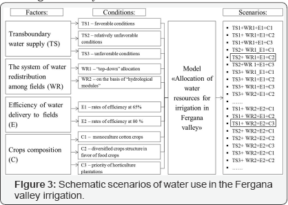
We have investigated two major scenarios of water and land use in the valley: "business as usual” (TS2WR1E1C2) and "optimal” (TS1WR2E2C3) (Figure 3). The scenarios of future climate were taken into account by modification of the irrigation norms for different crops (Figure 4). The irrigation norms established in the Soviet time, have been kept unchanged for a long period. Currently, the potential evapo transpiration in arid areas of Central Asia exceeds precipitation roughly by approximately 1500-2000 mm [24], which determines irrigation demand. In a warmer and dryer climate, this difference would increase, driving up crop irrigation norms. About forty SRES scenarios, several designated as the "marker" ones, are widely used in GCM simulations: the A1 family (which includes A1FI, A1B and A1T scenarios that mainly differ in their dependence on fossil fuels for energy production), B1, A2 and B2. Population and economy are the most important drivers of the scenarios.
Population growth is the highest in the A2 scenario, followed by B2, and A1 and B1. Economy growth is the highest in A1, followed by B1, B2 and A2. The gap between the rich and the poor closes most rapidly in the A1 scenario, followed by B1, B2 and A2. The energy intensity of the economy decreases in all four scenarios: faster in the B1 scenario, followed by A1, B2 and A2. The share of carbon-intensive fuels decreases in B1, A1B, and A1T, stays roughly constant in A1FI and B2, and increases in A2. Generally, A1 and A2 scenarios place more emphasis on economic growth, while B1 and B2 stress environmental sustainability; the A1 and B1 scenarios emphasize global solutions while A2 and B2 describe a more fragmented world [17].

The latest IPCC report proposed new set of emission scenarios. But SRES A2 has a similar trajectory to that of RCP8.5 in terms of both projected radiative forcing (W/m2) and global mean surface temperature change (°C) over the 21st century. SRES B1 has a similar trajectory with RCP4.5. [25]. Raskin [26] stated that most scenarios used in different disciplines could be grouped into several "archetypes": Economic optimism scenarios, Reformed market scenarios, Global sustainable development, Regional competition, Regional sustainable development. Kirilenko et al. [20] noticed that this grouping allowed combining climate and social-economic scenarios in one study. It was demonstrated on the example of the ABD (Asian Bank Development) social- economic scenarios for Central Asia [27] which were combined with climate scenarios [20]. Following this approach we suggest supplementing "the business as usual" scenario of water & land management in the Fergana Valley with SRES/A2 scenario (Regional competition archetype) as both prioritize regional identity and national interests. "The optimal scenario" of water & land management could be supplemented with SRES/B1 scenario (Reformed market archetype) as both assume economic policies that correct market failures, e.g. in respect to social development, poverty alleviation and environmental protection.
Results and Discussion
Consistent with some earlier estimates [13,15,28], we found the 2020s temperature change in 0.9oCto 2.1oC range compared to the 1961-1990 baseline period. The change in annual precipitation is inconsistent, ranging between small increase and small decrease. The projections for the 2050s demonstrate much higher temperatures increase between 1.7oC and 4.7oC. Finally, for the 2080s all GCMs simulate air temperature ranging from 3.9oC to 7.8oC. The precipitation change varies from -28mm (on the plains) to +128mm (in the mountains). Warmer summer temperatures increase the difference between potential evapotranspiration and precipitation (PET-P) by 13% in the 2020s, requiring 8% surge in water withdrawal for irrigation. By the 2050s, PET-P increases by 26%, requiring a 16% increase in irrigation water withdrawal. Finally, a sharp increase of air temperature in the 2080s elevates PET-P by 42% leading to a 25% increase in demand for water withdrawal for business-as- usual scenario [20].
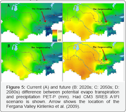
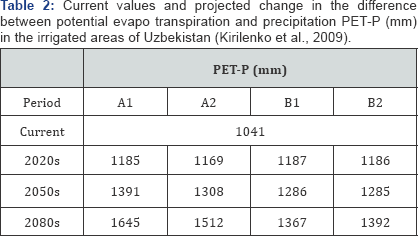
The impact of the climate change on the irrigation water requirements demonstrates considerable spatial heterogeneity (Figure 5). Due to a larger increase in precipitation and fewer irrigated fields, the upstream countries (Kyrgyzstan and Tajikistan) and Kazakhstan show no or very moderate increase in their irrigation water requirements, even though the relative change may become significant by the 2080s. Turkmenistan and Uzbekistan, heavily relying on irrigated agriculture and experiencing the smallest increase in precipitation, suffer the most as their irrigation requirements double by the 2080s. Uzbekistan, which heavily relies on rice and cotton asits major food and cash crops, would be impacted by a sharp 5.2oC temperature increase by the end of the century (average between the GCMs), with a small precipitation increase. The combination of high temperature growth with a small increase in precipitation would raise evapo transpiration rate (Table 2). Notably, the most extreme GCM simulations demonstrate an even higher warming of up to 8.3oC.
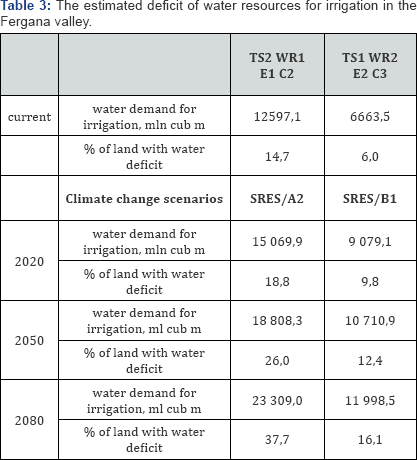
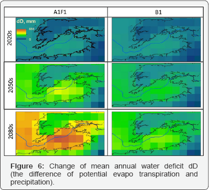
Following the regional pattern, in the Fergana Valley, the combination of high temperature growth with a small change in precipitation would increase annual water deficit (Figure 6) and, consequently, the irrigation water demand: by 14% in the 2020s, 23-33% in the 2050sand 30-56% in the 2080s, with the range determined by GCMs and SRES scenarios. Future precipitation and potential evapo transpiration are computed as a mean value from the temperature and precipitation output of five GCMs (CGCM2, CSIRO2, ECHAM4, HadCM3, and PCM) for three decades surrounding the 2020s, 2050s, and 2080s. Two contrasting CMIP3 scenarios, A1FI and B1 are shown. The estimated climate change impact on the water deficit in the Fergana valley for the observed scenarios is presented in (Table 3).
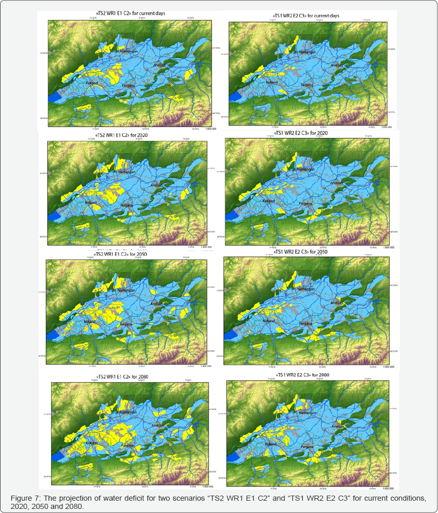
For the "business as usual" conditions of land & water management the share of lands with water deficit to irrigate will increase from 14, 7 % to 37.7 % by 2080. Besides huge water deficit there are high risks of water logging and salinization. The location of the lands with water deficit is primarily in the central parts within the territories irrigated by main cannels of the Fergana valley - the Big Andijan cannel and the Big Fergana cannel (Figure 7). The "optimal" scenario represents the restore of the Toktogul's irrigation mode and the advanced land use priorities to horticultural plantation with less water consumption and minimal environmental impact. We estimate that the described policy may contribute to less water deficit for currently (6 %) and slow growing rates (on 10 %) in future (Table 3). However the rising water demand will lead to water deficit in some areas as it is shown in (Figure 7).
In "optimal" scenario to mitigate local water deficit within Sokh, Isfara, Narin river fans and intermountain plains on the south and on the north of the valley (Figure 7), more groundwater can be applied. In current conditions the groundwater is primarily used for households and industrial needs while for irrigation it is exploited with limited character. According to Karimov et al. [29] the potential area for groundwater irrigation could be as much as 290 000 ha, for conjunctive use of groundwater and canal water - 243 000 ha. Existing technologies will allow increasing groundwater abstraction from 2,700 to 5,000-5,500 Mm3/year, mainly for irrigation purposes. Simple structures, such as infiltration basins and percolation from the riverbeds and floodplains, can be used in some of the aquifers, while deep underground dams are the only option for subsurface water banking in other aquifers. Collecting and using the water infiltrated from major canals into underground tanks could decrease risk of water logging and salinization on irrigated lands [29].
Conclusion
There are several domestic policies in the Fergana Valley which could make the "optimal” scenario feasible. After the collapse of the Soviet Union the Water User Associations (WUAs) emerged with the purpose to meet and solve the water management challenges. Implementation of water pricing may create additional incentives for improved water management and technological advances in Central Asia [30]. Transition to a new agricultural structure in the Fergana Valley is the most important measure to eliminate the area's water deficit [31-33]. Wider development of groundwater abstraction provides means to mitigate water deficit in certain areas of the Valley [33]. Therefore the shift of the land use structure to the horticulture plantations in the Fergana Valley must be the main strategy to improve water management, widely develop groundwater use for irrigation, and finally mitigate water deficit in the face of upcoming climate challenges [34,35].
For more Open Access Journals in Juniper Publishers please click on: https://juniperpublishers.business.site/
For more articles in Open Access Journal of
Environmental Sciences & Natural Resources please click on: https://juniperpublishers.com/ijesnr/
To know more about Open Access Journals
Publishers
To read more…Fulltext
please click on: https://juniperpublishers.com/ijesnr/IJESNR.MS.ID.555607.php



Comments
Post a Comment