Channel Flow and Depth Relationship in a Forested Stream in the Humid Tropical Environment, Niger Delta Nigeria - Juniper Publishers
Juniper Publishers- Open Access Journal of Environmental Sciences & Natural Resources
Channel Flow and Depth Relationship in a Forested Stream in the Humid Tropical Environment, Niger Delta Nigeria
Authored by Chukwu-Okeah Gift O
Abstract
The study was set to ascertain the relationship that exists between channel flow and depth in a forested stream, to achieve this study was poised to identify the type of flow prevalent in the forested stream, examine the relationship between channel flow and depth and ascertain variation in channel flow and channel depth in the different reaches in Chinda creek. To achieve this, velocity reading was taken from 30 sampling points which were identified as reaches in the 643.275m Chinda creek channel, velocity measurements was taken both on the surface and beneath precisely at 0.2m and 0.8m respectively with the use of a digital velocity metre and the channel depth was determined with the aid of a calibrated levelling staff. The study has carefully shown that a relationship exists between Channel Velocity and depth in the Chinda Creek but that the extent of their relationship is weak.
The R2 value for the relationship is 0.460. This explains that 46% of channel flow in the Chinda creek is explainable by depth. Hence, the depth of a river channel influences the extent of flow in that channel. The study also revealed that the type of flow in the channel is principally laminar, which connotes that the river is not erosive. On the characteristic attributes of the different sections of the river channel, the study revealed that there is a statistically significant variation in channel flow and channel depth in the different sampling points in Chinda creek.The study recommended the use of the channel because of the nature of its flow and depth status for ecotourism activities which will engender development in the area and increase government's revenue from the tourism industry.
Keywords: Depth; Velocity; Flow; Chinda Creek
Introduction
One of the factors affecting the shape of a river is the type of flow prevalent in the channel [1]. According to [2] experimental observations show that all velocity profiles in a flow in open channels is divided into parts on a straight line. Flows in channels behave differently based on the nature and characteristics of the medium in which they flow, in the open channel two types of flow have been identified amongst which are laminar and turbulent flow [2]. Laminar flow is a smooth straight flow of water in which water flows in sheets parallel to each other, thus it required least velocity and is often found in groundwater and near the stream bed. Turbulent flow is a higher velocity flow and its motion is irregular and forms eddies [3] as cited in [4]. Such turbulent flows often result in erosion of the river bed. Lastly, helicoidal flow is a corkscrew like flow which is commonly associated with formation of meanders. Velocity of the flow also affects the shape of a channel as it determines the kinetic energy the river possesses. Therefore, higher kinetic energy can result in greater erosion of banks and bed. Velocity is often controlled by the hydraulic radius, cross sectional area and channel roughness of the river.
Knowledge of the velocity is important in many hydraulic engineering applications. The velocity in wall-bounded flow is characterized by a momentum transfer towards the wall from zones of non-perturbed flow. Alluvial channels add a layer of complexity to any investigation into the flow field because of the ability of the boundary geometry to change with flow condition. In turn, those bed forms modify the flow adjacent to the wall. In experimental observations, it has been noted that in flow over a train of bed forms, a definitive momentum defect region is observed [5,6]. The region is associated with flow separation and wake formation downstream of the bed form lee face and as the wake is adverted downstream, the effect of the moment defect is diffused outward, causing the region to grow in depth [5].
Although no research reviewed, shows that velocity is a variable of interest in studying channel morphology dynamics, but rather discharge which is a sum of velocity and cross sectional area. As stated by [6] that one of the factors affecting the shape of a river is the type of flow in the channel, flow type is dependent on velocity of flow, as this determines the kinetic energy the flow possesses. Hence, velocity affects the shape of a channel. As depth of flow increases, near-bed velocity also increases, and streams can mobilize and transport the coarse sediment stored in the bed and banks [4-6]. Nearly all gravel channels are mantled by an armor layer containing particles larger than the underlying sediment.
The larger particles in the armor layer partly shield the finer particles from being dislodged by the flow, but are themselves more vulnerable to entrainment because they protrude into the high-velocity flow. As a result, large and small particles in the armor layer have nearly equal mobility, and so become entrained at nearly equal discharges [4]. Steep channels usually contain coarser bed material than gentle reaches, because the coarse sediment can be transported into and through the reach during common peak flows. In a study conducted by [5] as cited in [1], it is revealed that channel width, depth, and velocity generally increase downstream with the increasing volume of flow, while channel gradient and particle size commonly decline with distance from the divide. Therefore, water discharge which is dependent on the depth of the channel, sediment characteristics, and structural features can change greatly along the stream network.
Depth on its own is a function of channel slope, or gradient, which is the amount of vertical drop per unit of horizontal distance along a stream. The amount of energy available for sediment transport is directly related to slope - a steeper gradient gives a stream more energy to move larger particles, such as boulders. Although stream energy is not solely based on channel gradient (other factors such as channel geometry and hydraulic roughness are important), slope is a key factor in determining the channel's erosive capacity. Channel slope is closely related to a stream's position in the watershed, with slope decreasing in a downstream direction. Recent work focusing on steep channels has revealed a number of distinctions of fluvial form and process between steep, headwater streams in mountain environments and those in lowland channels (e.g., Jarrett 1990, Grant and Swanson 1995, Montgomery and Buffington 1997). For example, steep channels commonly have narrow and discontinuous floodplains [5], in contrast to lowland systems in which these channel forms are common.
The Problem
The role of depth in changes that occur in stream channels have not gained much attention, as many researchers have paid attention to other variables, thereby undermining the fact that most variables according to [4] as cited in Chukwu-Okeah, [2] depends on channel depth. Depth determines velocity and discharge of a channel. Therefore, the role of depth in channel morphology, noting its relationship with velocity informed its use in this study as a variable of interest. Flow in a channel has been identified as one of the factors affecting the shape of a river [1]. The relationship between channel flow and depth in Chinda creek is the focus of this study. The study is also poised to;
1. Identify the type of flow prevalent in the forested stream
2. Examine the relationship between channel flow and depth
3. Ascertain variation in channel flow and channel depth in the different reaches in Chinda creek
Study Area
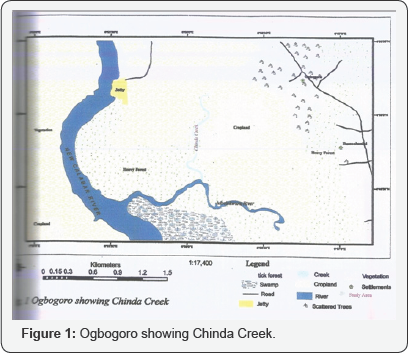
The study was conducted in Chinda creek in Ogbogoro town in Obio/Akpor local government area of Rivers State, which lies at latitude 4050'42.00''N and longitude 6055'44.10''. The community is about 1.37 kilometres away from the creek which lies at latitude 4050’2.43”N and longitude 6056’6.26”E. The total length of the creek to an adjoining creek called Okolo- Nbelekwuru is 1.93 kilometres, connecting to the New Calabar River, the total length is 3.04 kilometres. (www.googleearth. com) (Figure 1). The area lies on the recent coastal plain of the eastern Niger Delta. Its surface geology consists of fluvial sediments. This includes the recent sediments transported by Niger River distributaries and other rivers, such as Andoni, Bonny and New Calabar. In terms of general surface features, the area is very unique and falls within the coastal belt dominated by low lying coastal plain which belongs to the structural sedimentary formation of the recent Niger Delta. One of the most striking features of the region which Port Harcourt is located is the uniqueness of its surface drainage. Areola in Umeuduji and Aiseubeogun [2], described the drainage of the area as poor, essentially due to the combination of low relief, high temperature, high water table, high rainfall. The soils are organic in nature and essentially sandy in texture. The forest is densely thick with varieties of plant species commonly found in the areas are lianas, palm trees, epiphytes and other species of climbers. There is an existing ecological balance in the area. The area has the same weather condition like Port Harcourt as a region. The climatic condition is the tropical climate [6].
Methodology
Velocity reading was taken from 30 sampling points which were identified as reaches in the 643.275m Chinda creek channel, velocity measurements was taken both on the surface and beneath precisely at 0.2m and 0.8m respectively. This is because the flow depth of the river exceeds 0.76m (USGS, 1980) as cited in Chukwu-Okeah [3]. Therefore velocity meter measurements were taken at 0.2 and 0.8m of the flow depth, d. The mean velocity was obtained by averaging the velocities measured at 0.2 and 0.8m of the flow depth. Thus the mean velocity V, in the reach would be:
V = (V0.2 + V0.8)/2 (Equation 1)
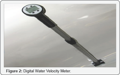
A digital water velocity meter was used in the velocity measurement for the entire channel (Figure 2). Channel depth determination was carried out with the aid of a calibrated levelling staff, this was done in the 30 sampling points in the river channel. To ascertain the influence of depth on channel flow in the Chinda creek, the linear regression statistical tool was used, the Froude number equation (see equation 2) was also used in determining the type of flow prevalent in the forested stream and the Pearson product correlation coefficient was used in examining the relationship between channel flow and depth.
Fe= v/Vgd ..................(Equation 2)
Where;
v = mean velocity of the channel
g= acceleration due to gravity (9.8m/s)
d = mean depth of the channel
The equation of the Froude number below was used to ascertain the nature of flow in the channel.
Analysis of Results
Determination of the type of Flow in the Channel
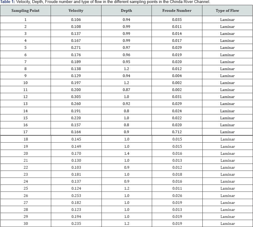
Using the fround number equation, the flow type in each of the sampling point along the channel was determined, hence the flow type for the thirty sampling points was ascertained. This was done on the basis of the criteria for froude number which states that since the froude number is a dimensionless equation, in any identified reach where the value is above 1 is said to be a turbulent flow and where the number is less than 1 is said to be laminar [1]. See the (Table 1) below. The table above reveals the channel depth, velocity, Froude number and type of flow experienced in the different section of the river. From the table above, it is obvious that the channel experiences laminar flow and hence is not very erosive.
Source: Researchers field work, 2016.
Relationship between Channel flow and Depth

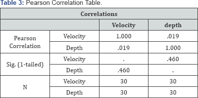
This section examines the extent of relationship between channel flow and channel depth in the Chinda Creek so as to determine how one influences the other (Tables 2 & 3). The above table shows that there is a positive relationship between Channel flow and Channel depth with a correlation coefficient of 0.019, the strenght of this relationship is weak although their relationship is not statitically significant at 95% significant level. The R2 value for the relationship is 0.460 This explains that 46% of channel flow is explainable by depth.
Variation in Channel flow and depth in different reaches Along the Chinda creek
In this section, care was taken in the manipulation of the data so as to ascertain if variation exist in channel flow and channel depth in different reaches in Chinda creek. The Analysis of Variance statistical tool was used. This is as shown below (Tables 4 & 5); The ANOVA table above reveals that calculated F statistics value for the analysis is 1092.882 while the critical value is 4.006873. Therefore since the calculated F value of 1092.882 is greater than the critical value of 4.006873 at F1 59 degree of freedom, the null hypothesis Ho of no significant variation is rejected and the alternate hypothesis H1 is accepted. Arising from the above, it is pertinent to note that the study has revealed that there is a statistically significant variation in channel flow and channel depth in the different sampling points in Chinda creek.


Conclusion and Recommendations
The study set out to examine the relationship that exists between channel velocity and channel depth in a forested stream in the Niger Delta area of Nigeria, so as to identify how one parameter affects the other. From the analysis carried out, the study has carefully shown that a relationship exists between Channel Velocity and depth in the Chinda Creek but that the extent of their relationship is weak. The R2 value for the relationship is 0.460. This explains that 46% of channel flow in the Chinda creek is explainable by depth. Hence, the depth of a river channel influences the extent of flow in that channel.
The study also revealed that the type of flow in the channel is principally laminar, which connotes that the river is not erosive. On the characteristic attributes of the different sections of the river channel, the study revealed that there is a statistically significant variation in channel flow and channel depth in the different sampling points in Chinda creek. Conclusively, the study recommends the use of the channel because of the nature of its flow and depth status for ecotourism activities which will engender development in the area and increase government's revenue from the tourism industry.
For more articles in Open Access Journal of Environmental Sciences & Natural Resources please click on: https://juniperpublishers.com/ijesnr/index.php




Comments
Post a Comment