Assesses the Resilience Index to Sea Level Rise Risk of Alexandria Governorate, Egypt - Juniper Publishers
Juniper Publishers-Open Access Journal of Environmental Sciences & Natural Resources
Assesses the Resilience Index to Sea Level Rise Risk of Alexandria Governorate, Egypt
Authored by Mamdouh M El-Hattab
Abstract
Alexandria Governorate is vulnerable to sea level rise risks, especially with its current high-density coastal communities and the rapidly increasing population rates. Most of the Governorate’s inhabitants are living in the low-lying land and some are even below sea level. Moreover, the Governorate has been identified as one of the ‘Mediterranean vulnerable sites’. This paper assesses the resilience of Alexandria Governorate to sea level rise risk, focusing on hazard assessment (Inundation) as one of the most significant physical impacts. Resilience index to SLR for each district in the study area is developed using vulnerable built-up areas, vulnerable population and socioeconomic conditions (represented in the unemployment rate, annual population growth and Human Development Index (HDI).
Keywords: Alexandria Governorate; Sea level rise (SLR); Resilience; Socioeconomic Conditions; Human Development Index (HDI)
Introduction
Egypt is considered one of the top five countries expected to be most impacted with SLR due to allow elevation in the Nile delta region El-Raey [1], Frihy [2], Batisha [3], El-Hattab [4] Soha [5]. Alexandria Governorate as the second capital of Egypt is built on a narrow and partially elevated coastal ridge facing the sea and is exposed to many environmental problems such as SLR, tsunami, earthquake, flood by rain and other risks [1]. Moreover, informal areas, which house one-third of Alexandria’s total population, deteriorating infrastructure in an old and dense part of the Governorate [6] and fast urbanization of surrounding areas over reclaimed wetlands and other low-lying areas make the Governorate particularly vulnerable to these hazards. Previous studies proved that Alexandria is one of the most vulnerable Governorates to SLR Alexandria is vulnerable to SLR because of its natural topography of flat, low land El-Raey [7-9]. Moreover, the urbanization process in Alexandria is rapidly increasing, putting pressure on infrastructure and services that limit resilience and the capacity to cope SLR. The higher percentage of the population located in Low Elevation Coastal Zones (LECZ), making the Governorate vulnerable to the risks of SLR. With about 80% of the population living within 100 km of the coast, this has led to a concentration of economic activity and livelihoods in coastal mega cities.
IPCC, in its Third Assessment report, defined resilience as the “amount of change or amount of pressure a system can undergo without changing state” [10]. A more detailed definition, provided by the AR5 of the IPCC defined resilience as “the capacity of a social-ecological system to cope with a hazardous event or disturbance, responding or reorganizing in ways that maintain its essential function, identity, and structure, while also maintaining the capacity for adaptation, learning, and transformation” Arctic Council [11]. Onneshan [12] defined Resilience refers to the capacity of an individual or community to cope with stress, overcome adversity or adapt positively to change. Some risk factors, such as drought, unemployment, or a lack of services, may exist at a community-wide level. Resilience is defined as “the ability of a system to withstand or accommodate stresses and shocks such as climate impacts, while still maintaining its function” [13-15].
Onneshan [12] classified resilience into ecological and social. A measure of how much disturbance an ecosystem can handle without shifting qualitatively into a different state. It is the capacity of a system to both withstand shocks and to rebuild itself after damage. The ability of human communities to withstand and recover from stresses such as environmental change, social and economic or political upheaval. Resilience is what enables the exposed elements to withstand, cope and recover from disaster impacts Noy and Yonson [15]. In terms of disaster risk reduction priorities, vulnerability is typically linked to prevention, preparedness, and mitigation; while resilience, to rehabilitation, reconstruction, and recovery. According to a logical sequence of events (pre-event, disaster and post-event situation), are avulnerability, resilience (pre-event), hazard, risk (disaster), damage, and loss (post-event) Modica and Zoboli [16]. UKaid [17] expressed risk as a function of hazard exposure, vulnerability and coping capacity (Risk = Hazard x Vulnerability / Resilience).
Study Area
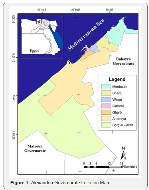
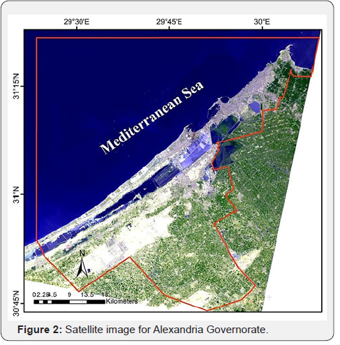
Alexandria Governorate is located approximately between 30°50’ to 31°40’ north and 29°40’ to 32°35’ east. The Governorate has a waterfront that extends for 60 km, from Abu-Qir Bay in the east to Sidi Krier in the west and includes a number of beaches and harbors. It extends about (32 km) along the coast of the Mediterranean Sea in north-central Egypt. It lies northwest of the Nile delta and occupies a T-shaped peninsula. Alexandria is bounded by the Mediterranean Sea in the north, Buhayra Governorate in the east and the south, and Matrouh Governorate in the west as shown (Figure 1). While, Alexandria Governorate is extended in the longitudinal direction, to accommodate the growth in population, between the Mediterranean coast and Mary out Lake (Mareotis) that gave the Governorate a semi rectangle shape with more than 30 km length and around 6 km width (Figure 2). Alexandria is an urban Governorate that includes Alexandria Governorate, the new industrial town and Borg El-Arab district [18]. States that the current boundary of the urban agglomeration of Alexandria Governorate consists of seven districts (15 sections (Qism) and 129 Shyakha), Al- Montazah, Sharq (East), Wasat (Middle), Gharb (West), Al- Gomrok, Al-Agami, and Al-Amereya, along with the Borg Al Arab Governorate and three villages.
Materials and Materials
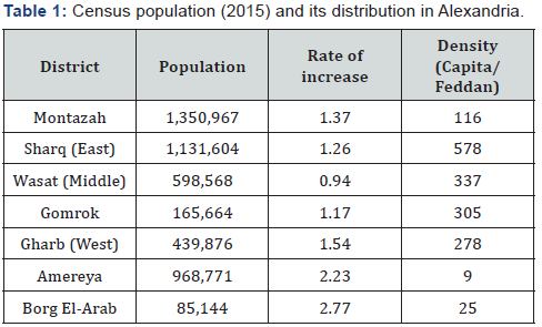
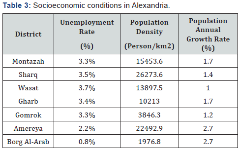
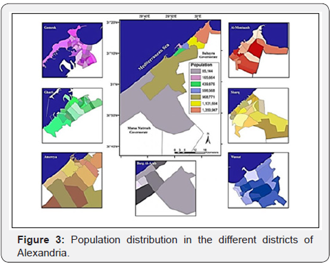
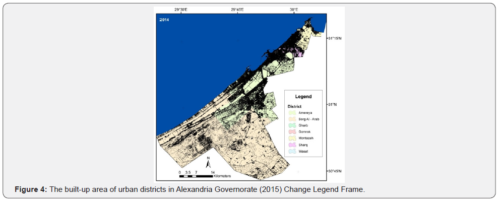
ASTER (Advanced Space-borne Thermal Emission and Reflection Radiometer) GDEM Version 2 (GDEM2) data and LANDDSAT OLI (2015) satellite image covering the study area were used. Population census in 2015 is 4,700,088.18 according to CAPMAS [19]. The spatial distribution of the population was found to be rather uneven between the different districts of Alexandria, with the inner district, Wasat, reaching its saturation level as seen in (Figure 3). The results of the last census in each district of Alexandria population according to CAPMAS [19] are given in (Table 1). The average rate of increase in the whole Governorate was 1.36%. Built-up areas of Alexandria Governorate are presented in (Table 2) and (Figure 3). The unemployment rate ranged between 0.85% in Borg Al-Arab and 3.75% in Wasat [19] as seen in (Table 3).

Method
Assessing of urban resilience of Alexandria Governorate to SLR impacts was performed in four steps:
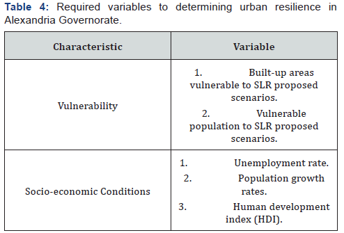
a) Identify and calculate the required variables for determining urban resilience in Alexandria Governorate according to (Table 4).
b) The ASTER GDEM imagery was used to generate contour lines, which were used as the elevation data. The elevation data was prepared in WGS 1984 (UTM Zone 35) coordinate system.
c) The vulnerability of urban districts of Alexandria Governorate is assessed by the identification of the spatial extent of SLR impacts inundations using the proposed scenarios of SLR and land subsidence of the Alexandria.
d) The inundation maps are overlaid on the population map of the Alexandria Governorate to estimate the vulnerable population.
e) All variable (vulnerable built-up areas, vulnerable population, unemployment rate, annual population growth and human development index (HDI) are normalized using Equation 1 to obtain values ranging from 0 to 1.FAO [20].

Where:
Nx = Normalized variable
X = absolute value of the variable being normalized
Xmin = Minimum variable value
Xmax = Maximum variable value
f) Calculate the resilience index to quantify urban resilience of the Alexandria Governorate and integrate the different variables that determine resilience to SLR impacts. Six variables are integrated into the proposed composite index, including proportions of built-up area vulnerable to SLR, vulnerable population and socioeconomic conditions (represented in the unemployment rate, annual population growth and human development index (HDI) which reflecting health, education, income levels in the community).
g) All previous variables are integrated into the resilience composite index using an equal weighting scheme using Equation 2 Abdrabo and Hassaan [21].

Where:
R = Resilience index
Nx = Normalized variable value
Nx = Normalized variable value
h) Resilience index is ranged between 0 and 1 reflecting lowest and the highest level of resilience, respectively.
Results and Discussion
The results are composed of three sections; the first section presents the results of the physical vulnerability to SLR inundation. In the second section, the calculation of the human development index is discussed. The final section introduced the resilience index.
Vulnerability
Vulnerability relates to a number of factors, as the study aims to assess the resilience of urban community to SLR, it is necessary to include both of vulnerable built-up area and vulnerable population using four proposed scenarios.
Vulnerable Built-up Area
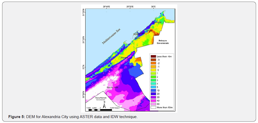
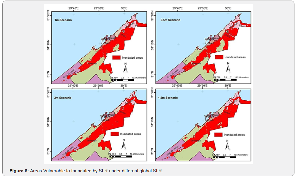
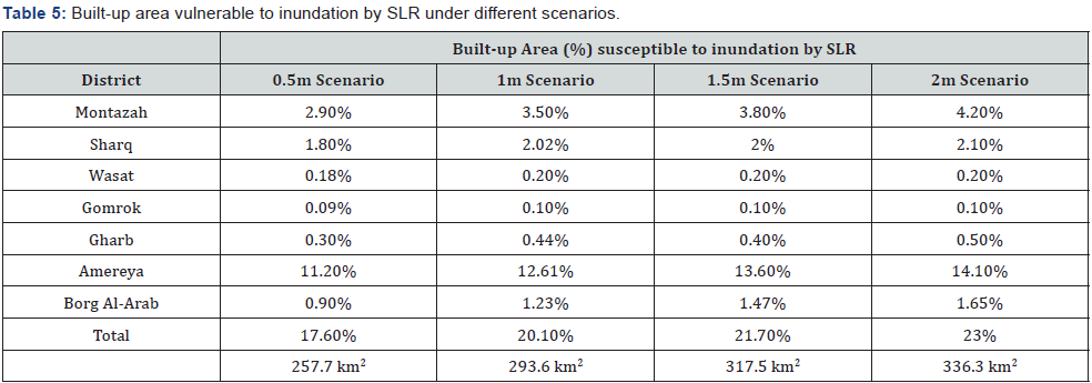
For identifying areas susceptible to SLR, four scenarios are proposed 0.5, 1,1.5 and 2 m. ASTER DEM (30 m) was used to carry out the analyses by extracting the areas that could be vulnerable to inundation based on the different scenarios. DEM was created using Inverse distance weighted interpolation technique of the ASTER data as seen in Figure 4 shows the elevation of the area ranges between 0 and 67 m above sea level. Vulnerable built-up areas to SLR inundation are presented in (Table 5). Figure 5 shows the spatial extent of inundation under different inundation scenarios. The total area of these seven urban districts is 1459.6 km2. The total built-up areas susceptible to inundation by SLR in these districts ranged between 257.7 and 336.3 km2, representing 17.6% and 23% of their total built-up areas. The spatial extent of SLR impacts differs widely among these urban districts. For instance, the proportions of inundated built-up areas in urban districts are found to be highest in the case of Amereya district ranging between 11.2% and 14.1% of its total built-up area under the 0.5m and the 2m scenarios, respectively. The lowest built-up area susceptible to inundation was found to be in Gomrok district, ranging between 0.09% and 0.1% of its total built-up area under the 0.5m and 1m scenarios, respectively Figure 6.
Vulnerable Population
In order to estimate the population vulnerable to inundation by SLR, it was assumed that populations are evenly distributed over the built-up area of these urban areas. Table 5 shows that the total vulnerable population in the seven urban districts ranged between 44.5% and 56.4%of total population under 0.5 m and 2 m respectively. It was found that Montazah district has the largest vulnerable population size of all districts studied (Table 6). Borg Al-Arab had, meanwhile, the smallest vulnerable population size under all SLR proposed scenarios.

Socio-economic Conditions
Socio comes from social, and refers to any number of demographic and social conditions, such as the age structure. Economic refers to the economic conditions, such as income, unemployment rates. Socio-economic is used as an umbrella term to cover a wide variety of interrelated social and economic factors. Socio-economic conditions in this study include unemployment rate, population growth rate and HDI.
Unemployment Rate
The unemployment rate is the share of the labor force that is jobless, expressed as a percentage. When the economy is in poor shape and jobs are scarce, the unemployment rate can be expected to rise. When the economy is growing at a healthy rate and jobs are relatively plentiful, it can be expected to fall. The unemployment rate is seen in Table 4. The highest rate is found in Wasat district (3.7%) while the lowest rate in Borg Al-Arab district (0.8%). Both of Montazah and Gomrok districts have the same unemployment rate.
Population Growth Rate
Egypt is the most populous Arab country, with an estimated population of 87 million [19]. The population is currently growing at 1.6% per year (2013), producing obstructing economic growth. Euro monitor International’s report, Global Economies, and Consumers [22] put Alexandria in its list of the fastest-growing cities in terms of population. Population grows to the extent that the number or rate of births exceeds the number or rate of deaths. The difference between these numbers (or rates) is termed “natural increase” (or “natural decrease” if deaths exceed births). Table 7 shows the number of births, deaths and natural increase in Alexandria Governorate.

Human Development Index (HDI)
The Human Development Index (HDI) was developed by the United Nations as a metric to assess the social and economic development levels of countries. Four principal areas of examination are used to rank countries: mean years of schooling, expected years of schooling, life expectancy at birth and gross national income per capita.
Life Expectancy Index (LEI)
Life expectancy at birth is the number of years a newborn infant could expect to live if prevailing patterns of age-specific mortality rates at the time of birth stay the same throughout the infant’s life. According to UNDP [23], Life expectancy index can be calculated from the next equation:

The minimum value of life expectancy is 20 years; the Maximum value of life expectancy is 83.5 years (Japan, 2015). A LEU is 1 when Life expectancy at birth is 83.5 and 0 when Life expectancy at birth is 20.

Life expectancy index in Alexandria Governorate in 2012 is 0.66; (Table 8) presents the life expectancy for different districts in Alexandria.

Education Index (EI)
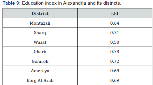
Education Index (EI) consists of two indices which are: Mean year of school (MSY) and the Expected school year (ESY) UNDP [23]. MSY is the number of years’ person spent in school. The lower value was fixed and the maximum value for mean years of school is fixed at 15 according to UNDP [23]. An average number of completed years of education of a population is 25 years and older. ESY is a measure of the number of years of schooling a child at the start of education trajectory is expected to receive if current rates of acceptance are maintained throughout the child life [24]. (Number of years a child of school entrance age can expect to spend at a given level of education). The ESY is calculated to be 18 years according to UNDP [23].
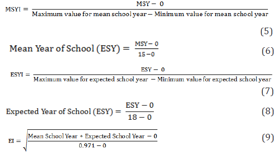
Education index in Alexandria C in 2012 is 0.71; (Table 9) presents the education index for different districts in Alexandria.
Income Index (II): According to UNDP [23], the HDI index calculation for income is:
The minimum value for gross national income (GNI) per capita is $100 UNDP [23], the maximum value for gross national income (GNI) per capita is 123124 [24]. So, Equation 10 is modified to be:

The minimum value for gross national income (GNI) per capita is $100 UNDP [23], the maximum value for gross national income (GNI) per capita is 123124 [24]. So, Equation 10 is modified to be:

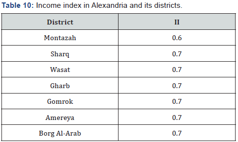
Income index in Alexandria Governorate in 2012 is 0.7. (Table 10) presents the income index for different districts in Alexandria.
Finally, Human Development Index (HDI) can be calculated using [23] formula:

Where
LEL = Life Expectancy Index;
EI = Education Index;
II = Income Index
From Equation 13, HDI for Alexandria urban districts can be calculated as presented in (Table 11).
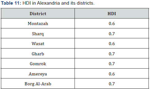
Thus HDI for Alexandria Governorate is the average of the HDI in all districts (0.7).
The estimated resilience index, derived for urban areas susceptible to inundation by SLR in the study area, is shown in Table 12. Ranking the seven urban districts according to resilience index reveals that Borg Al-Arab district had the lowest resilience level with a resilience index value in the four SLR scenarios. Sharq district had the highest resilience value under the 0.5 m and 1 m SLR scenarios. Whereas, Montazah had the highest resilience value under both of 1.5 m and 2 m SLR scenarios respectively. The resilience index ranges from 0 (low resilience) to 1 (high resilience).The lowest level of resilience in the case of Borg Al-Arab district can be attributed to the low proportion of the population and built-up areas vulnerable to inundation by SLR and a relatively low coverage of infrastructure and services. The high resilience in Sharq district can be explained by the relatively high HDI, high levels of access to basic services and infrastructure, and improved environmental and demographic conditions.

The lack of resilience in urban to SLR may have far reaching implications to Egypt as a whole. Variation in resilience value in urban districts can be attributed to a different area, population density, assets, socioeconomic conditions, capabilities and consequently different levels of resilience of urban districts to SLR impacts. Also, functionalities influence resilience value as urban districts of Alexandria is multi-functional, as they serve as tourist resorts host in addition to a number of economic activities such as industrial and commercial activities.
Conclusion
Alexandria Governorate is considered one of the most vulnerable areas to SLR. The resilience index of the seven urban districts to SLR risk is assessed. The resilience index was developed to integrate various physical and socioeconomic variables that determine urban resilience. The index is calculated depending on the use of six variables (number of vulnerable population, inundated area, the unemployment rate, population density, the annual population increase the human development index and HDI). HDI (reflecting health, education, income levels in the community) of Alexandria and its districts was calculated. HDI is an indicator adopted by the United Nations Development Program since 1990 to determine the status of human development in a particular country. HDI is based on three indices: life expectancy at birth index, education index, and income index. The human development index of Alexandria is 0.70.
The application of the resilience index showed that urban districts revealed different levels of resilience to SLR impacts. It was found that the level of resilience was varied in the seven urban districts of Alexandria Governorate. Such varied resilience levels can be attributed to different magnitudes of physical vulnerability to inundation by SLR, which varied considerably among urban districts. The results indicated the highest resilience districts are Sharq, Montazah, Amereya, Wasat Gomrok, Gharb and finally Borg Al-Arab district which has the minimum resilience. High resilience value does not mean that a specific event will not affect the facility and will not cause severe consequences. Conversely, a low resilience value does not mean that a disruptive event will automatically lead to a failure of the critical infrastructure and to serious consequences. The resilience instead compares the level of resilience at critical infrastructures and guides prioritization of limited resources for improving resilience. The resilience also provides valuable information effective way for preventing problems and improving welfare. The results proved that the resilience does not necessarily mean that a community is invulnerable- a community can be resilient and vulnerable at the same time.
Socio economic aspects influence resilience as lack basic infrastructure and services, which is typically accompanied by overcrowded living conditions and poor housing quality. In addition, environmental aspects adversely affect resilience such as the deteriorating quality of the urban environment, due to pollution, urban water and air quality and overexploitation of natural resources. The current coastal zone management strategies and the institutional settings involve limited contribution to urban resilience beside the overlap and conflict between these institutions. The governmental authorities are characterized by centralization in addition to the lack of vertical and horizontal integration that reveals gaps and conflicting positions between governing bodies.
To know more about Juniper Publishers please click on: https://juniperpublishers.com/manuscript-guidelines.php
For more articles in Open Access Journal of Environmental Sciences & Natural Resources please click on: https://juniperpublishers.com/ijesnr/index.php



Comments
Post a Comment